10 September 2023
Roaring River Ranger Station to Junction Meadow
(18 miles, +5,000/-4,200 feet).
Today sucked.
Oh well. I knew that it would. Even with good weather it would be a lot of climbing (mostly) without views and then a repeat of terrain that I have already seen several times.
But then the rain.
My third rain storm in 3 days.
When the NOAA said 0% chance of rain.
And my Garmin still says 0% chance of rain.
Sigh.
It was raining lightly when I packed up this morning. Of course. But without good information about how long this improbable precipitation would persist, I pressed onward.
I had four choices.
1) Climb back up the Elizabeth Pass Trail (nope!).
2) Climb over Colby Pass (12,000 feet and maybe still impacted by snow, and then back down to the swamp at the Kern before rejoining the High Sierra Trail - no thank you!).
3) Take the Sugarloaf Trail back to Silliman Pass (15 miles, mostly between 7,000 and 9,000 feet - a slog for sure - and then a repeat of what I did last summer).
And 4) the Avalanche Pass Trail.
Option 4 seems the least problematic. It was a new trail for me, the pass is only 10,000 feet, and it would put me onto the Bubbs Creek Trail, which I hoped would be better maintained than the trails out here.
The trail climbs almost 1,000 feet right out of the gate, which was helpful for getting out of the mess and into some nice views.
But the more I climbed, the more it rained. It was comical. My feet were already soaked when I got to my first opportunity for a dry foot crossing.
I passed through a burn area where there were grasses I could not identify that glowed. They briefly improved my mood.
I reached some meadows that were quite pretty, but the trail was choked with soaked foliage and I frequently had to check my GPS to stay on track.
Which is hard to do when it’s raining on your phone.
I don’t know why I was surprised, but just below avalanche pass was…. an avalanche of blowdowns.
And then finally:
It was raining pretty hard at the top. I stopped to take a break crouched under a tree and mistakenly removed my headphones from the USB port of my phone. After that my phone said there was liquid in there, so it wouldn’t let me plug them back in.
So no music to help with the monotony and discomfort.
Oh well.
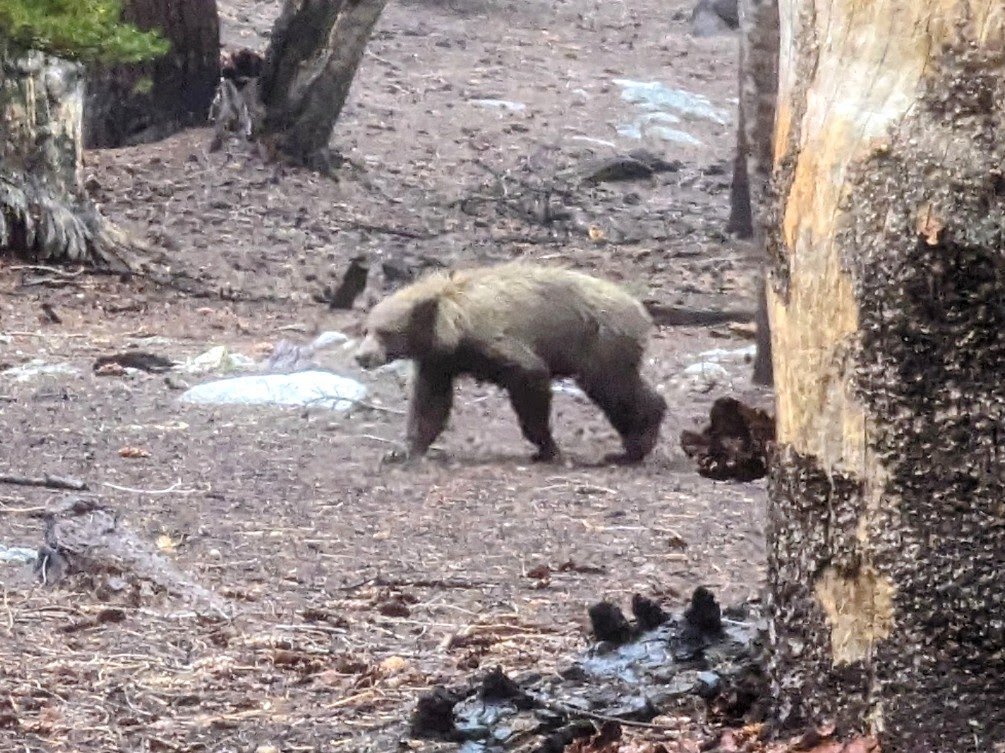
Feeling very sorry for myself, I started the long descent to Bubbs Creek. And then I saw this:
And shortly after that, the rain finally started to let up. It gradually turned to a fine mist as I descended to the Sphinx Creek crossing.
And after that, my spirits were greatly lifted by the views down into Bubbs Creek canyon.
There is some impressive infrastructure in the last 2,000 feet of the descent. It reminded me a little of the Golden Staircase below Palisade Lakes.
I found a spot on one of the switchbacks to eat lunch under a tree, sitting and out of the rain for the first time all day.
And the last bit of descent was quite nice.
But I started to worry. I didn’t know if there was a bridge over Bubbs Creek. Its omnipresent roar worried me as I approached the low point for the day. And to play one more joke on me, Nature camouflaged the bridge quite well.
But it worked just the same. And I was finally back on a familiar trail.
I got cocky, thinking that just because I was now on one of the most popular loops in the Sierra, the miles would fly by. But what I forgot was this: the most popular entry to that loop, Road’s End, was permanently closed this year due to road damage. So no hikers. And worse, no one to maintain the trail.
I couldn’t believe how wild it seemed. Overgrown with sopping wet ferns, and choked with dozens of blowdowns. In just one year it had gone feral.
I was so frustrated. At many points I was hiking only one mile an hour, less than half my normal pace on a trail like this.
And I was thrown off by the fact that I was completely alone. I had seen no one since the ranger last night. Where is everybody? Am I the only crazy person trying to hike out here at the end of this snowy Sierra summer?
I pulled into Junction Meadow. There was still enough daylight to get to Vidette Meadow, but I had had it. I know the numbers don’t show it, but this felt like one of my hardest hiking days ever. I was thoroughly defeated.
At the intersection with the trail to Reflection Lake, I turned left, found the first flat spot in the trees, fought yet another cloud of mosquitoes to set up my tent, and then dove in. It was a full two hours before dark, but within one I was asleep.
